Sale, offer 08-904

Investment land 16,55 ha, Lubsko (Górzyn cadastral district)

Lubsko

Plot area
16.55 ha
Net price
Price on request
Local zoning plan
1PSB, 2PSB, 3PSB
Electricity infrastructure land (3E)
Max. building height
12 m
  • 16,5467 ha in 9 cadastral plots
  • Largest plot 1784: 6,8625 ha
  • Environmental decision for an industrial facility (2021)
Property details

At a glance

A complex of 9 plots with a total area of 16,5467 ha in the gmina of Lubsko (żarski county).

An environmental decision has been issued for part of the land for a dross processing facility.

Teren inwestycyjny 16,55 ha, Lubsko (obręb Górzyn) - zdjęcie 1

Property

The offer comprises nine cadastral plots with a total area of 16,5467 ha, located in the gmina of Lubsko in żarski county (Lubuskie voivodeship). The largest is plot no. 1784, with an area of 6,8625 ha. The remaining plots range in area from 0,3694 ha to 1,8845 ha: 1601/7 (0,8761 ha), 1601/8 (0,8603 ha), 1601/9 (1,6482 ha), 1601/11 (1,7480 ha), 1601/12 (0,3694 ha), 1601/13 (1,8845 ha), 1601/14 (1,8093 ha) and 1775/2 (0,4884 ha).

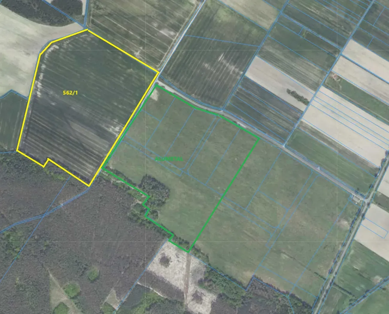
Most of the land lies in one contiguous area. This allows it to be developed as a single complex for production, warehouse or logistics use. The land is currently undeveloped and open in character. The orthophotomap shows a forest complex to the south and agricultural land to the north and east. An access road runs nearby.

For some of the plots (1601/7, 1601/8, 1601/9, 1601/11 and 1775/2, Górzyn cadastral district), the Mayor of Lubsko issued an environmental decision on 18 March 2021. It covers the project entitled construction of a dross processing facility in Lubsko. The facility was to process salt slag generated in the production of secondary aluminium casting alloys. The decision also covered plots 1601/6, 1601/10, 1601/11, 1775/3 and 1775/4, some of which may have been subdivided later.

The project described in the decision provided for a production and warehouse hall with a reinforced concrete or steel column structure, measuring 116 x 120 m and approx. 8-10 m high, and an oxide warehouse measuring 48 x 120 m. These parameters show that the land is suitable for large-volume industrial buildings. The decision supports further investment procedures. However, its validity and scope must be verified for a specific project.

Detailed zoning conditions, site utilities, price and transaction structure are agreed individually. Please contact InvestPoland to obtain the full property documentation.
  • Total area: 16,5467 ha
  • 9 cadastral plots in the gmina of Lubsko
  • Largest plot: no. 1784, 6,8625 ha
  • Environmental decision of 18 March 2021 (ref. GKO.6220.9.2020)
  • The decision concerns a facility processing salt slag from the production of secondary aluminium alloys
  • Planned production and warehouse hall 116 x 120 m, height approx. 8-10 m
  • Planned oxide warehouse 48 x 120 m

Location and zoning

The property is located in the gmina of Lubsko in żarski county, in Lubuskie voivodeship, in the Górzyn cadastral district. Access is by a road running along the boundary of the land, visible on the cadastral map. To the south, the land borders a forest complex.

Location analysis

Property plots

Checking public registers: plots, zoning plans, land classes, nature protection, flood risk and statistics.

Gallery

Book a site visit

We will show you the property on site and share documents in the Data Room after an NDA is signed.

We'll call you

Leave your number, we'll call back within one business day

Data Room

Property documents for investors

Register extracts, building design, connection conditions, valuation report. Access after signing a non-disclosure agreement (NDA).